Why riding the same road twice draws one line on the map
Because both passes are on the same road: the two GPS traces land on top of each other, so the map draws one line where you rode two. A ride out and back, a lap ridden twice, a road you took again on the way home — the second pass paints over the first, and with it the colours and the direction of the leg underneath.
Roveri separates them into lanes. It reads the whole track when the ride opens, finds the stretches you covered more than once, and draws each pass on the side the GPS already puts it on — or, where the two are too close together to measure, on the side its pass order gives it. Both lines carry arrows for the way you were going. Nothing on disk moves — it is a drawing rule, on by default, free, and a single toggle in Settings puts the plain line back.
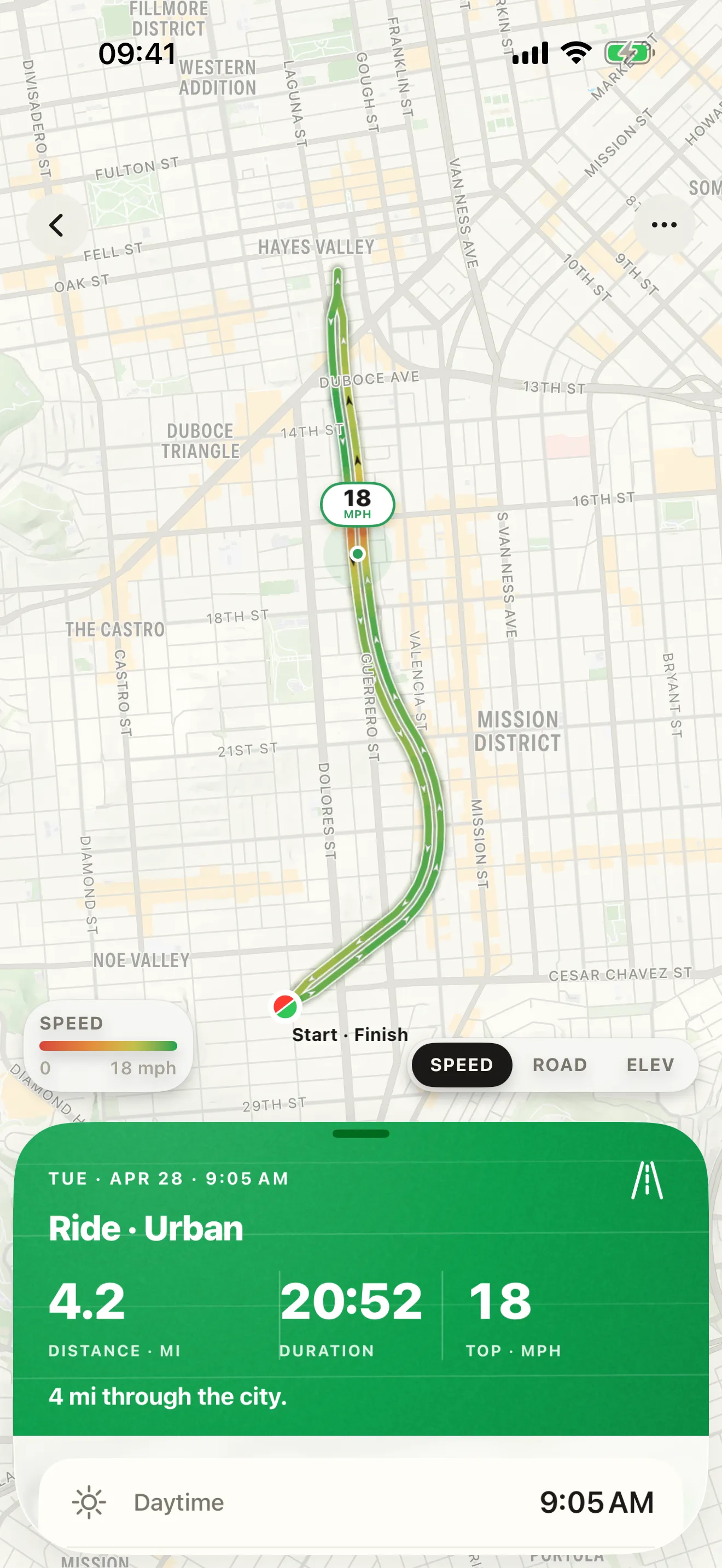
What you are seeing
A GPS track is a list of points, and a map draws them in the order they were recorded. Ride east down a road and back up it an hour later and the return leg is drawn second, straight over the first — same road, same points, same pixels. The outbound leg is still there, still recorded, still counted; it is simply underneath. That is why a ride that leaves home and comes back looks, at the fit-the-whole-ride zoom, like a single line with a single dot on it.
It costs you three things at once. The colours of the leg underneath are gone, so a fast run out reads as whatever the slow crawl home painted over it. The shape of the ride is gone, because an out-and-back and a one-way ride draw exactly the same picture. And the direction is gone: with both ends of the ride on the same spot, nothing on the map says which way round you went.
Why it is not the GPS being wrong
The instinct is that the phone lost precision — that it should have known you were on the other side of the road. It is worth being clear about this, because the answer shapes everything Roveri does with it.
A lane is about three to four metres wide. An iPhone recording at its best accuracy is good to roughly five metres on an open road. So the real separation between your two passes is smaller than the noise on any single point: from one fix alone, which side of the road you were on is not knowable, and an app that claimed otherwise would be inventing it.
What is knowable is the average. Over a shared stretch of road there are hundreds of pairs of points, and across hundreds of pairs the noise cancels while the width of the road does not. So Roveri never asks the question of a single point. It compares the two passes along the whole stretch they have in common, takes the mean offset, and gives each leg the side that the mean already shows. Your track is unchanged, and the drawing is honest about where the information came from.
It is honest about the other case too. Where the mean comes out under a metre — the two passes ran on the same tarmac, or the fixes drifted the separation away — there is nothing left to read, and Roveri stops pretending there is: it falls back to the order you rode the passes in, drawing the first to one side and the second to the other. You still get two readable lines; what you do not get is a claim about which side of the road you were on, because the track no longer carries one.
The pairing rule is deliberately narrow, so that ordinary riding does not turn into lanes. Two points count as the same ground when they are within about twenty metres of each other, when the two moments are at least three hundred metres apart along the track, and when the headings are parallel. Shared stretches shorter than about a hundred metres are dropped altogether. A crossroads is one point on the ground and stays one point on the map; a hairpin is not two passes of one road; brushing past your own track on the next street over is not a corridor.
What it looks like on a real ride
An out-and-back. The classic. Ride a road out, turn round, ride it back, and both legs get their own line with their own colours, close enough together to read as one road and far apart enough to read as two. The gap is constant on screen rather than on the ground, so it looks the same zoomed out over the whole ride as it does zoomed in on one street.
A fuel stop at the turnaround. Stopping for twenty minutes splits the ride into two recorded segments, and older drawing code would treat them as unrelated lines. Roveri looks at the whole track before it draws any of it, so the leg before the stop and the leg after it still find each other and still get their two lanes.
A track day, or any road ridden three and four times. Repeated passes in the same direction have no natural side to fall on — you were in the same lane every time. Roveri lays them out in the order you rode them, so lap one and lap three sit beside each other rather than on top, each with arrows pointing the way they went. Up to four passes get their own line before the picture stops adding lanes.
Where the passes part. At each end of a shared stretch the two lines slide back together, so the map shows you exactly where the ride stopped repeating itself and went somewhere new.
Arrows, and the dot that says Start · Finish
Direction is the other half of a legible loop, so every lane carries chevrons along it. They sit at a fixed spacing on screen: dense GPS never beads them into a solid line, and zooming out never makes them disappear. They appear on all three map layers — Speed, Road type and Elevation — with the ink chosen per stretch so they stay readable on a pale elevation step as well as on a dark green one.
And where a ride ends where it began, the two endpoint markers become one: a single disc, green on the start half and red on the finish half, labelled Start · Finish. Zoom in far enough that the two are genuinely apart on the street and it splits back into a green start and a red finish, because at that zoom they are two different places again.
Turning it off
Lanes are on for every rider, free, and are not part of Roveri Pro. If you would rather have the plain trace, open Settings and turn off Lanes on the route map — one toggle, which governs the lane offsets and the direction arrows together, on your own map and on everything you send out of the app. The merged Start · Finish disc is not affected by it: one dot in one place is right either way.
The same ride, shared
A ride you send as a link opens on a page at roveri.app with the same reading: the passes drawn apart, the same arrows along them, and one marker where the start and the finish are the same place. The card you export as an image carries the lanes too, in its own style — without the arrows, because a card is a picture rather than a map to be read.
All three of those follow the toggle above. Leave Lanes on the route map on and the shared page, the card and the exported file carry the same reading your own map shows; turn it off and each of them draws one merged line instead — the setting governs what leaves the app as well as what you see.
Export the ride as a GPX file with lanes on, and the lane each point belongs to
travels with it, in the roveri:lane field of the Roveri GPX
extensions. It is a drawing hint, not a change to your coordinates:
every other app reads the file as the plain track it has always been. With the
toggle off the file carries no roveri:lane at all, and the track itself is
identical either way.
LANES ON THE ROUTE MAP
Two passes, two lines.
Where a ride covers the same road twice, Roveri draws each pass on the side the GPS already puts it on — or, where the passes are too close together to measure, on the side their order gives them — with arrows along both for the direction you were going, and collapses a coincident start and finish into one Start · Finish disc. It is worked out from your recorded track each time the ride opens, and it changes nothing that was stored.
- Both legs keep their own speed, road-type and elevation colours
- Direction arrows on every layer, at a constant spacing on screen
- Right in Japan and the UK without a setting — where the passes are far enough apart to measure, the side comes from your GPS
Common questions
Does lane separation change my recorded track?
It does not. The track on disk is exactly the points your iPhone recorded; the lanes are worked out when you open the ride and applied while the map is drawn. Turn the toggle off and the same ride draws the way it always did.
Does it work in countries that ride on the left?
Yes, and with nothing to set. Where the two passes are far enough apart to measure — about a metre or more, which an ordinary lane clears — the side each is drawn on comes from your own GPS trace rather than from a driving-side rule, so a ride in Japan or the UK is pushed further left where you rode on the left, and a ride in France is pushed right. Where the passes ran on the same tarmac there is no side to read, and Roveri separates them by the order you rode them instead.
Can I turn the lanes off?
Yes. Settings has one toggle called Lanes on the route map, on by default, which governs the lane offsets and the direction arrows together — on your own map, on a ride you share as a link or a card, and in a GPX file you export. It is free for every rider and is not part of Roveri Pro.
Do the lanes change the distance of my ride?
They do not. Distance, moving time, speeds and elevation are all measured from the recorded points, and the lane offset is applied afterwards, in screen space, for drawing only. The numbers on the ride are identical with the toggle on and off.
Why does one dot say Start · Finish?
Because your ride ended where it began, and two markers on one spot hide each other — the finish paints over the start. Roveri merges them into a single disc, green on the start half and red on the finish half. Zoom in until the two points are genuinely apart and it splits back into a green start and a red finish.
Lanes are part of Roveri, a riding journal for iPhone (iOS 18.6 or later), free to download with an optional Pro tier. Recording rides, your full history, the route map with its lanes and arrows, and the shareable ride card are free; Pro adds the Coverage Atlas, a per-ride elevation profile, the climate measured along your route, GPX export, Where to ride, and the rest of the monthly Rewind story. Read the full, code-verified fact sheet on the Roveri press page, or get Roveri on the App Store.